Carmenta Server
Technical Specification
Carmenta Server 4.9
General
- Carmenta Server provides a complete solution for making geospatial data available through standard web services.
- It has broad support for open industry and de-facto standards with certified compliance for many Open Geospatial Consortium (OGC) interface specifications.
- Designed for use in mission-critical solutions, it has a proven record of reliability and is used in a number of 24/7 installations.
- A clear and straightforward setup with tools that ease integration into various IT infrastructures.
- Powered by a very fast map engine core and with efficient use of hardware resources, it delivers excellent performance when deployed in high-capacity websites.
Technical features
- Native reading of geospatial data from more than 100 file formats, spatial databases and sensor data sources. No need for offline format transformations.
- Built on top of a powerful map engine capable of performing advanced on-the-fly geoprocessing. Terrain analysis functions such as Slope and Line-of-Sight calculations are performed server-side with high performance and both raster and vector data can be used from multiple data sources simultaneously.
- Create and maintain data catalogues over GIS datasets and services with standardized catalogue and metadata tools. The catalog server supports automatic and time-scheduled metadata harvesting from multiple sources and it can be extended through plug-ins for adding new sources for harvesting. Once harvested, the metadata can be rapidly searched, categorized and filtered in a range of different ways.
- All system administration tasks are carried out with an easy-to-use web-based tool. With all settings safely stored in a database, version upgrades are easy and hassle-free.
- Easy-to-use tools enable you to import new maps and publish services. Maps created and maintained by common desktop GIS tools are easily imported and published. ISO metadata is automatically generated when publishing new services and it can be changed and extended using the built-in editor function.
- A smart disk and memory tile caching utility is fully integrated that allow map tiles to be dynamically generated from any geodata source. All settings, such as tile-size and tiling schemes are easily configured and time constraints can be set on the cache to automatically re-load tiles.
- A built-in proxy utility can be used to “cascade” data from external OGC services and re-publish as hosted services. “White-lists” of authorized services are used to ensure that only trusted sources are connected.
- Carmenta Server comes bundled with Carmenta Web Explorer, a JavaScript-based web browser application based on the open-source libraries Openlayers for 2D maps and Cesium for 3D maps. The map application is used for previewing published map services and may in addition serve as base for larger web applications requiring map functionality or be integrated in a larger web application. Adapted for responsive behavior, the web client can be used on a wide range of HW platforms, including mobile devices.
- GUI components are also included to ease the setup of Geoportal browser clients. These can be used to keep track of datasets as well as available online services. The Geoportal client includes tools to allow free text searches, setting category filters, spatial filters or a combination.
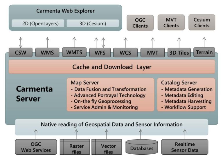
- Below is an overview of the Carmenta Server Architecture sketching out important system parts and emphasizing the dataflow from source to user.
- For high performance vector maps, Carmenta Server supports tiled vector data following the Mapbox Vector Tile (MVT) specification. The transfer of tiled vector data is compressed and encoded using the Google Protobuf (PBF) format, while still being fully cacheable by the Carmenta Server disk and memory caching utility.
- Cesium 3D Tiles and Terrain mesh services allow 3D web map clients based on the Cesium open-source library to render realistic and high resolution 3D maps, including detailed city models.
- A full-featured Software Development Kit (SDK) is available for rapid map website development and configuration. It contains documentation, sample projects and “Carmenta Studio”, Carmenta’s powerful map configuration tool that is used to set all parameters that control map rendering and connections to data sources. The tool is also used to set scale intervals for layer visibility in clients and uses a graphical data-flow tool to setup and configure geoprocessing “pipelines” for more advanced services.
- Visualization of vector features and symbols defined in the server-side configuration can be re-used in the map client by using symbol and visualization services in the map server.
- The SDK is also used to test and fine tune map configurations before deployment in production environments.
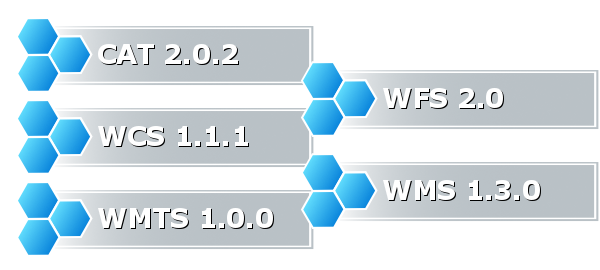
- A high-performance Web Map Service (WMS) can be setup for publishing geodata from any GIS data source. Carmenta Server has compliant support for OGC WMS 1.3.0 interface, and also supports the 1.1.1 specification, with flexible layer control and auto-publishing of dynamic legends. The service interface has support for the DGIWG WMS profile. It also has an integrated Feature Portrayal Service (FPS) capable of rendering features from external feature services. Styled Layer Descriptor/Symbol Encoding (SLD/SE) can be used to update map portrayal from clients.
- Tiled Map Services are fully supported through either the WMS-C interface or the OGC WMTS. These interfaces benefit greatly from Carmenta Server’s built-in tile caching utility. The service interface has support for the DGIWG WMTS profile.
- Geodata from any vector data source can be published through a very flexible Web Feature Service (WFS). It has compliant support for the OGC WFS 2.0.0 interface, and also supports the 1.1.0 specification. The WFS can publish feature data, either as GeoJSON, GML or binary objects, which is easily controlled via settings in the map configuration. Multiple vector data sources can be read simultaneously and all data model and coordinate transformations are done on-the-fly. Automatic GZIP compression can be invoked in the service to reduce package size.
- INSPIRE compliant download services can be easily launched through the WFS interface, and the product contains a framework for setting up automatic transformations from customer specific data models to the Data Theme models mandated by INSPIRE requirements. Downloading of features packaged in the ESRI Shapefile format is also supported.
- Web Coverage Services (WCS) can be used to retrieve or download raster or matrix data such as elevation data, meteorological grids or maritime depth data. Carmenta Server has compliant support for the OGC WCS 1.1.1 interface, and also supports the 1.1.2 specification. It automatically transforms any source raster format to those mandated by the WCS specification. GeoTIFF is normally used as a transport format.
- An advanced bookmark function, based on the OGC OWS Context standard, can be used to save client status and settings. An Atom/RSS service for news feed can then be used to distribute the settings.
- Carmenta Server offers an integrated Catalog Server solution for gathering, searching, updating and publishing information about GIS data and metadata. ISO standard metadata models (ISO19115/19139) are used. Compliant support for Catalogue Service for Web (CSW) 2.0.2 is included and distributed search can be used when connected to other CSW services. Automatic and time-scheduled harvesting of metadata can be invoked to keep the data catalogue updated.
Carmenta Server Core 2024.1
General
- Carmenta Server Core provides a complete solution for making geospatial data available through standard web services on Docker containers or Podman.
- It has broad support for open industry and de-facto standards with certified compliance for many Open Geospatial Consortium (OGC) interface specifications.
- Designed for use in mission-critical solutions, it has a proven record of reliability and is used in a number of 24/7 installations.
- Powered by a very fast map engine core and with efficient use of hardware resources, it delivers excellent performance when deployed in high-capacity websites and cloud environments.
Technical Features
- Native reading of geospatial data from more than 100 file formats, spatial databases and sensor data sources. No need for offline format transformations.
- Built on top of the powerful map engine Carmenta Engine, capable of performing advanced on-the-fly geoprocessing. Terrain analysis functions such as Slope and Line-of-Sight calculations are performed server-side with high performance, using both raster and vector data from multiple data sources simultaneously.
- All system administration tasks are carried out with a scriptable settings interface, used when creating new container images based on Carmenta Server Core or at run time when containers are started.
- A service list web page allows monitoring and verification of published services. Maps created and maintained by common desktop GIS tools are easily imported and published. ISO metadata is automatically generated when publishing new services.
- A smart disk and memory tile caching utility is fully integrated that allow map tiles to be dynamically generated from any geodata source. All settings, such as tile-size and tiling schemes are easily configured and time constraints can be set on the cache to automatically re-load tiles.
- A built-in proxy utility can be used to “cascade” data from external OGC services and re-publish as hosted services. “White-lists” of authorized services are used to ensure that only trusted sources are connected.
- Support for Kubernetes readiness and liveness probes, as well as various resource metrics for use with Prometheus and Grafana.
- Carmenta Server Core comes bundled with Carmenta Web Explorer, a JavaScript-based web browser application based on the open-source libraries OpenLayers for 2D maps and Cesium for 3D maps. The map application is used for previewing published map services and also contains sample tools for interaction with analysis services.
- Below is an overview of the Carmenta Server Core Architecture sketching out important system parts and emphasizing the dataflow from source to user.
![]()
- A full-featured Software Development Kit (SDK) is available for rapid map website development and configuration. It contains documentation, sample projects and “Carmenta Studio”, Carmenta’s powerful map configuration tool that is used to set all parameters that control map rendering and connections to data sources. The tool is also used to set scale intervals for layer visibility in clients and uses a graphical data-flow tool to setup and configure geoprocessing “pipelines” for more advanced services.
- Visualization of vector features and symbols defined in the server-side configuration can be re-used in the map client by using symbol and visualization services in the map server.
- The SDK is also used to test and fine tune map configurations before deployment in production environments.
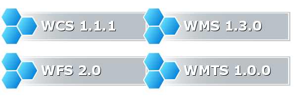
- A high-performance Web Map Service (WMS) can be setup for publishing geodata from any GIS data source. Carmenta Server Core has compliant support for OGC WMS 1.3.0 interface, and also supports the 1.1.1 specification, with flexible layer control and auto-publishing of dynamic legends. The service interface has support for the DGIWG WMS profile. It also has an integrated Feature Portrayal Service (FPS) capable of rendering features from external feature services. Styled Layer Descriptor/Symbol Encoding (SLD/SE) can be used to update map portrayal from clients.
- Tiled Map Services are fully supported with the OGC WMS-C and WMTS interfaces, as well as a general XYZ interface supporting OpenStreetMap Slippy Maps. These interfaces benefit greatly from Carmenta Server Core’s built-in tile caching utility. The service interface has support for the DGIWG WMTS profile.
- Geodata from any vector data source can be published through a very flexible Web Feature Service (WFS). It has compliant support for the OGC WFS 2.0.0 interface, and also supports the 1.1.0 specification. The WFS can publish feature data, either as GeoJSON, GML or binary objects, which is easily controlled via settings in the map configuration. Multiple vector data sources can be read simultaneously and all data model and coordinate transformations are done on-the-fly. Automatic GZIP compression can be invoked in the service to reduce package size.
- INSPIRE compliant download services can be easily launched through the WFS interface, and the product contains a framework for setting up automatic transformations from customer specific data models to the Data Theme models mandated by INSPIRE requirements. Downloading of features packaged in the ESRI Shapefile format is also supported.
- Web Coverage Services (WCS) can be used to retrieve or download raster or matrix data such as elevation data, meteorological grids or maritime depth data. Carmenta Server Core has compliant support for the OGC WCS 1.1.1 interface, and also supports the 1.1.2 specification. It automatically transforms any source raster format to those mandated by the WCS specification. GeoTIFF is normally used as a transport format.
- An advanced bookmark function, based on the OGC OWS Context standard, can be used to save client status and settings. An Atom/RSS service for news feed can then be used to distribute the settings.
- Carmenta Server Core offers an OGC Web Map Context (WMC) service that allow clients to retrieve comprehensive information about all published services, including their endpoints, map layers, keywords, coordinate reference systems, extent and many other metadata information.
- For high performance vector maps, Carmenta Server Core supports tiled vector data following the Mapbox Vector Tile (MVT) specification. The transfer of tiled vector data is compressed and encoded using the Google Protobuf (PBF) format, while still being fully cacheable by the Carmenta Server Core disk and memory caching utility.
- Cesium 3D Tiles and Terrain mesh services allow 3D web map clients based on the Cesium open-source library to render realistic and high resolution 3D maps, including detailed city models.
System Requirements – Carmenta server 4.9
Development environment
Operating Systems:
- Windows 10 (64-bit)
- Windows 11
Software requirements:
- IIS 10.0 or later
- .NET Framework 4.7.2 or later
- .NET 8.0 or later (ASP.NET Core Runtime Hosting Bundle or .NET SDK)
Language requirements:
- .NET Standard API: .NET Standard 2.0 or later
Deployment environment
Operating Systems:
- Windows Server 2016
- Windows Server 2019
- Windows Server 2022
Software requirements:
- IIS 10.0 or later
- .NET Framework 4.7.2 or later
- .NET 8.0
Hardware recommendations – Development
- CPU: Minimum quad-core CPU
- RAM: Minimum 8 GB RAM
- Disk space: At least 10 GB free disk space
Hardware recommendations – Deployment
- CPU: At least one quad-core Xeon-class CPU, or other server-grade CPU. More CPUs and/or more CPU cores per CPU will result in more map server instances running in parallel.
- RAM: At least 8 GB or more. More RAM will allow more caching of geodata in map server instances, and a larger map tile memory cache.
- Disk space: Depends on the size of the geodata and the size of a map tile disk cache. Typically at least 100 GB free disk space is needed. Fast disks such as hardware RAID or similar will increase the server performance significantly.
Note: Due to its architecture with internal scaling by running multiple map server instances if possible, Carmenta Server will make use of available hardware in an efficient and optimal way, to ensure maximum performance.
On multi-core CPUs and/or multi-CPU systems, the CPU cores are typically used as follows:
- One CPU core is used for the IIS working process, Tile Store and other Windows processes.
- The remaining CPU cores will allow multiple map server instances to run (typically the number of map server instances will equal the number of CPU cores minus one).
System Requirements – Carmenta Server Core 2024.1
Development Environment
Operating Systems:
- Windows 10 (64-bit)
- Windows 11
- Red Hat Enterprise Linux 8 or 9
- SUS Linux Enterprise 15 SP4
- Ubuntu 20.04 and 22.04 LTS
Software requirements:
- Docker Desktop Community or Enterprise or Podman
Language requirements:
- .NET 8.0 or later (ASP.NET Core Runtime Hosting Bundle or .NET SDK)
Deployment Environment
Operating Systems:
- Windows Server 2019
- Ubuntu 20.04 LTS or later
Cloud environments:
- Amazon Elastic Container Service (ECS)
- Azure Container Instances (ACI)
- Azure Kubernetes Service (AKS)
- Azure Web App for Containers
Hardware recommendations
Generally speaking, the hardware requirements for Carmenta Server Core are flexible and largely determined by the number of map services being published and their characteristics (type of geodata, rendering and caching requirements etc.).
Due to its architecture with internal scaling up of multiple map server instances if possible, Carmenta Server Core will make use of all hardware that is allocated to it, to ensure maximum performance.
The minimum recommended hardware configuration for a Carmenta Server Core container is:
- Number of CPUs: 4
Note: More will allow multiple map server instances in the container (normally the number of map server instances will equal the number of CPUs minus one) - RAM: 4 GB
Note: More RAM will allow more caching of geodata, and a larger map tile memory cache (if applicable). Some map services may require a certain amount of RAM to be loaded and published. - Disk space: Depends on the size of the geodata and the size of a map tile disk cache (if applicable).
Note: The disk space may be allocated internally in the container, or on a mounted external volume.
Try for free
Request a Trial
Are you ready to see how our products can transform your work? Request a free trial today and explore the full potential of our geospatial technology.
- Our Evaluation License includes 30 days unlimited access.
- Please specify which product/products you are interested in.
- Fill out the form, and one of our representatives will contact you shortly with access details.
This form can be used to request a trial for Carmenta Engine, Carmenta Server or Carmenta Map Builder.