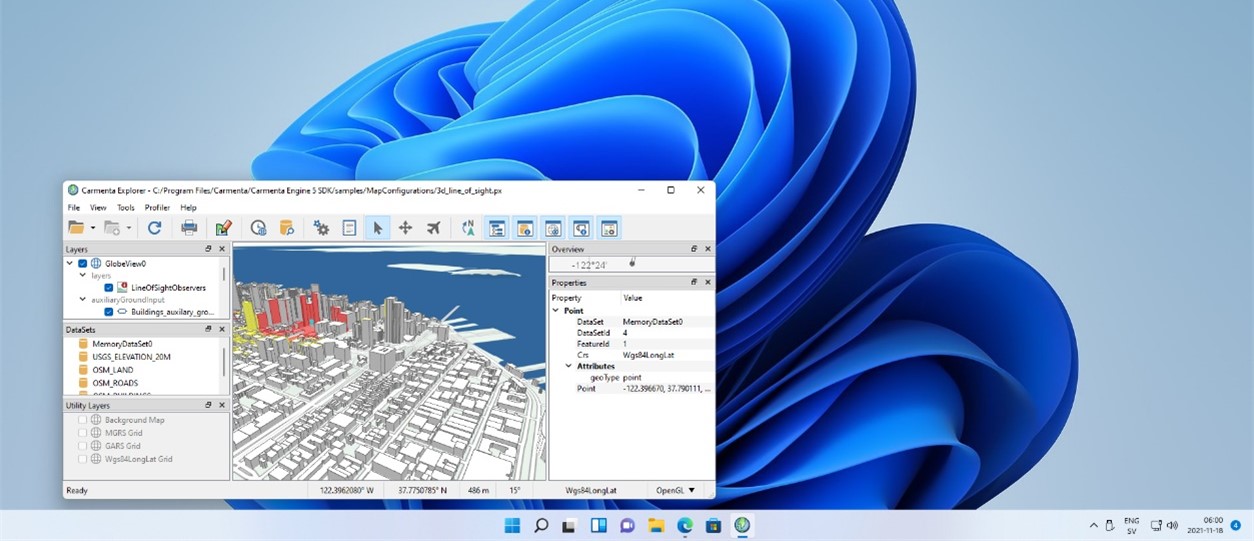
Carmenta Engine 5.15
This release introduces the ability to use Carmenta Engine for embedded development on Linux ARM, as well as adding Windows 11 as a supported operating system.
Other improvements include direct reading of GRIB files for meteorological visualization, as well as support for tactical graphics in MIL-STD-2525D and NATO APP-6(D) military symbol standards, and a greatly improved visibility index calculation, read more about the release here.

Carmenta Engine for Linux ARM
Carmenta Engine for Linux SDK now supports deploying applications on Linux ARM platforms. This makes it easy to use low end ARM based hardware in onboard systems for different applications.
The functionality in Carmenta Engine for Linux ARM is the same as on all other platforms and has been requested by customers as an addition to Carmenta Engine’s support for Windows, Android and Linux x86.
Carmenta Engine supports Microsoft Windows 11
This release of Carmenta Engine SDK adds support for the recently released Microsoft Windows 11.
With Microsoft Windows 11 as a supported platform for Carmenta Engine SDK, you can both be sure that the application you build today can run on early adopter systems, as well as be used for a long time into the future.
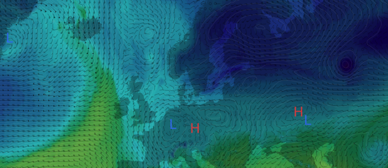
Displaying weather forecasts from GRIB files
The new GribDataSet makes it possible to read meteorological data in the GRIB format, and the output can be used as any raster in Carmenta Engine, either for direct visualization, or as input to other geoprocessing operators.
With the new PointSampleOperator you can sample raster values into attributes on point features, and this can be used together with the new WindBarbSymbol that makes it easy to visualize wind direction and speed. The PointSampleOperator can be used for many other use cases where you would like to sample raster data and is available for all Carmenta Engine users without any additional extensions required.
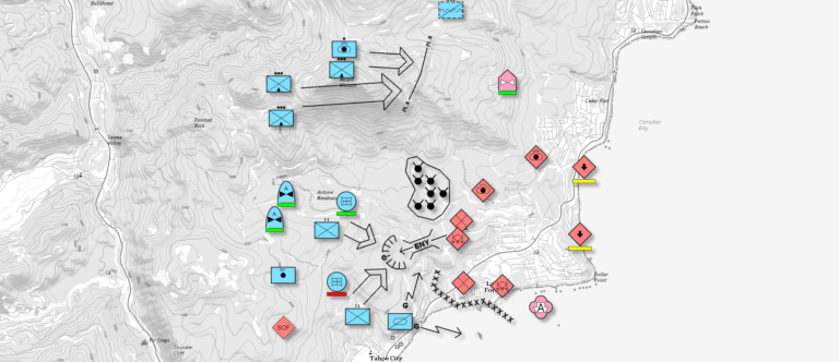
Support for Tactical Graphics in MIL-STD-2525D and NATO APP-6 D
The Tactical Extension has been updated to support tactical graphics from the US MIL-STD-2525D and NATO APP-6(D) symbol standards, in addition to the point symbology that was added in Carmenta Engine 5.14.
This expands the capabilities for tactical visualization in Carmenta Engine that is used in many customer systems and has been verified in multinational environments.
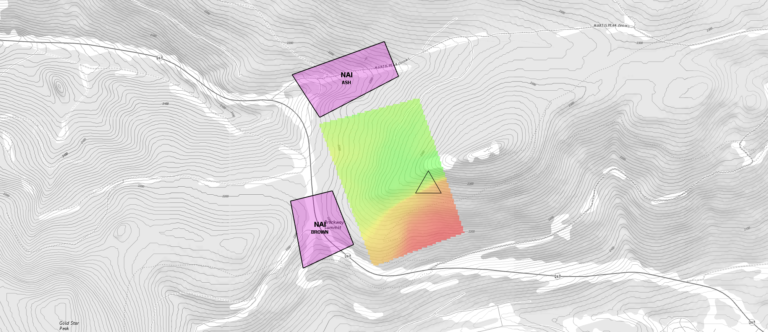
Improved visibility calculations
With the improved VisibilityIndexOperator you can now assign both an observer area and multiple target areas. This makes it possible for you to calculate where to place an observer to see as much as possible of your targets, and where you should be located to avoid being seen. This can aid commanders in their planning, as well as be used in simulation and machine learning applications.
Additional functionality for OGC GeoPackage Files
OGC® GeoPackage Metadata Extension
Carmenta Engine now supports parts of the OGC GeoPackage Metadata extension, both for reading and writing. This makes it possible to save the ISO metadata that Carmenta Engine today can handle for datasets directly in the OGC Geopackage, instead of storing it in separate XML files.
OGC GeoPackage WKT for Coordinate Reference Systems Extension
We have added support for the OGC GeoPackage WKT for Coordinate Reference Systems extension, that makes it possible to save projections both in WKT and WKT2 in OGC Geopackage. This improves Carmenta Engines handling of OGC Geopackages from different providers and makes it future proof for new projection definitions.
Community Extension for MVT data in OGC GeoPackage
With this addition to Carmenta Engine we make it possible to read Mapbox Vector Tiles data from OGC GeoPackage files using the Vector Tiles Community Extension. This makes it possible for customers that wants to use vector tiles in other projections than Google Maps Compatible to do so, and this improves accuracy of vector tiles-based maps in, among other things, polar areas.
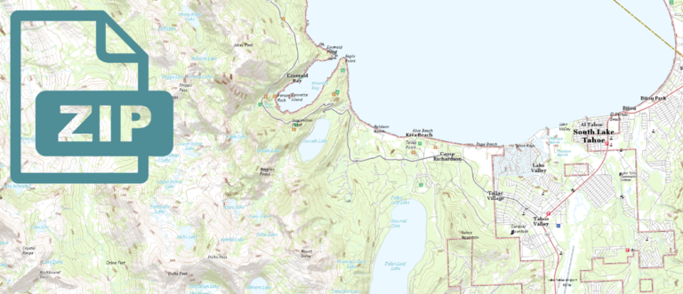
Bundling of resources
Carmenta Engine can now efficiently read configuration files, geodata and other resources directly from zip-based bundles, without having to unpack them to the local file system. This makes it possible to deploy entire self-contained maps as single files.
In addition to bundling all configuration resources in a zip-based bundle, small resource files, such as raster symbol images, can now be embedded directly into configuration files, so that the original files do not need to be deployed separately.
Catalog Extension enhancements
A single Catalog instance can now load catalog services from multiple locations, including directly from zip-based bundles. This makes it easy to store your geodata and configurations over multiple disks if you wish to. The new class CatalogLoadDataSetSet makes it also possible to use datasets from a Catalog directly in a configuration file, without extra application code.
Using the two enhancements to Catalog Extension together, makes it easy to bundle up geodata and other resources into different geodata packages, that you can copy between different deployed systems, on all supported platforms, without any need to convert data between different formats.
Custom dataset enhancements
When working with custom datasets, you can now supply DataSetInfo information and handle DataSetInfo.FromFile requests, just like for the built-in formats in Carmenta Engine, and OrdinaryLayer now supports dynamic caching of features returned from CustomDataSet implementations for better handling of dynamic data.
Other Notable Improvements
Preload data in TileLayer
TileLayer can now be configured to preload data to reduce the visible tiling artifacts using the new preloadBehavior property.
OGC 3D Tiles support
It is now possible to use OGC 3D Tiles data sets efficiently in GlobeView, if you package them using the new MapPackageModelWriter.
Reading of Mapbox raster
The MapPackageDataSet can now read Mapbox Raster Tiles from .mbtiles files. The MvtDataSet, introduced in Carmenta Engine 5.12 can be used for reading Mapbox Vector Tiles from such files.
Visualization of nautical charts
The S52Visualizer can now remove overlapping labels in the nautical charts.
Additions to Expression syntax
Added several math functions to the expression language, like abs, sqrt, cos, sin, and exp.
Raster cache updates
The raster cache feature has been updated: It now provides better compression, especially for RGB/RGBA data, and the raster cache is often faster to generate.
Improved handling of database timeouts
The new DatabaseDataSet properties ConnectTimeout and CommandTimeout provide improved control of database timeouts, and the new method DatabaseDataSet.StartConnect allows multiple database datasets to establish their server connections in parallel.