Carmenta Engine 5.7
The new version of Carmenta Engine provides on-the-fly calculation of the terrain and obstacle clearance of flight routes, as well as support for commercial nautical charts in the IHO S-63 format.
Other major improvements include the ability to add full-text indexes to any vector data source to enable fast address and point of interest search and a new aggregation algorithm that can be used to declutter military tactical overlays based on the order of battle (ORBAT).
On-the-fly Terrain and Obstacle Clearance Calculation
The new VerticalClearanceOperator can be used to calculate the clearance of a flight route over terrain and vector obstacles. The high performance calculation is based on the same algorithms as Carmenta Engine’s existing vertical profile calculation, which makes it highly suitable for use in a dynamic scenario such as when interactively planning the route.
The output of the calculation is not only the clearance for each route leg, but also detailed information about the clearance for each obstacle, the highest points in the terrain etc.
This makes it possible to visualize the clearance in a very informative way. An example is provided below.
![]()
A route passing over mountainous terrain with various point and area obstacles. VerticalClearanceOperator is used to display terrain and obstacle clearance and to highlight dangerous areas.
IHO S-63 Nautical Chart Support
Carmenta Engine can now read and visualize commercial nautical charts that use the IHO S-63 Data Protection Scheme.
This functionality complements the existing support for reading charts in the unencrypted IHO S-57 format. Both S-57 and S-63 data can be visualized according to the IHO S-52 presentation standard.
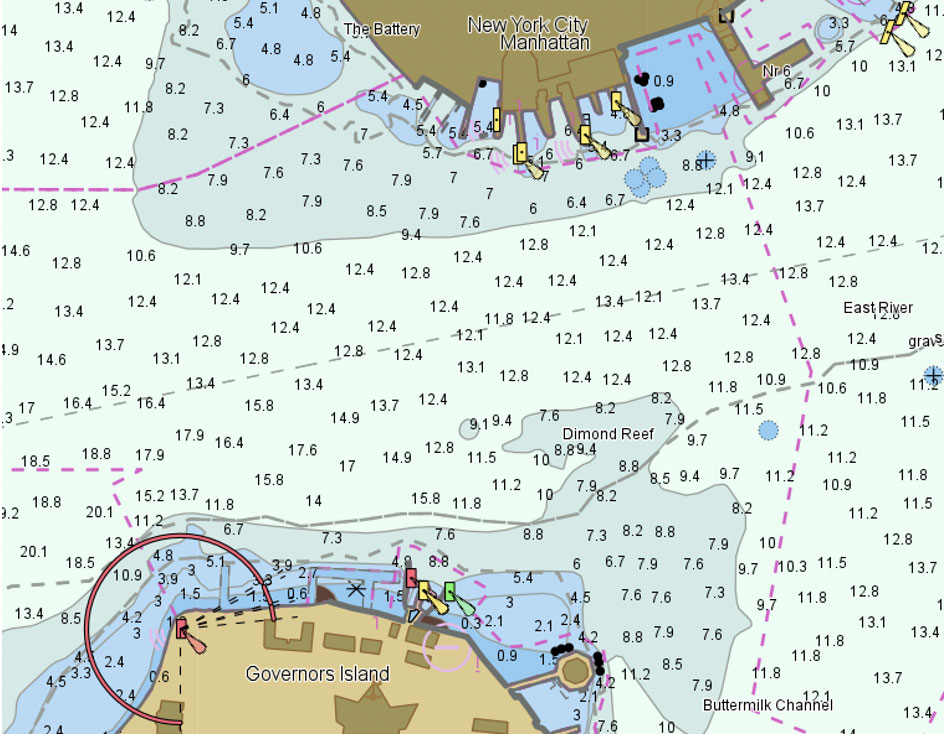
A vector based nautical chart visualized by Carmenta Engine according to IHO S-52.
Automatic Aggregation of Hierarchical Data
The new AggregatingLayer can be used to declutter objects in a hierarchical structure, e.g. the ORBAT hierarchy of a tactical scenario. The aggregation can either be fully automatic – based on object overlap – or controlled by the application.
AggregatingLayer can also generate a graph of the hierarchical structure, as well as bounding polygons for each level in the hierarchy. Applications can use these features to further enhance the situational awareness for the end user.
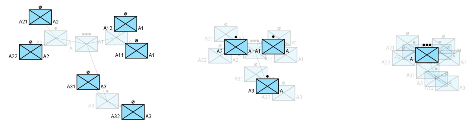
An example of how AggregatingLayer can declutter a tactical overlay based on the ORBAT. With the same tactical situation shown in three different scales, AggregatingLayer automatically displays either individual teams, squads or the entire platoon.
Full-text Indexes
It is now possible to add full-text indexes to any Carmenta Engine vector dataset. This enables virtually instantaneous lookups of features based on free text search strings. Partial queries are supported and the results are ranked according to how well they match the search string.
A common use case for this functionality is to add address search functionality to an application, such as in the example below. But it can for example also be used to provide quick lookup of aeronautical features in an ARINC-424 database based on ICAO and IATA codes.
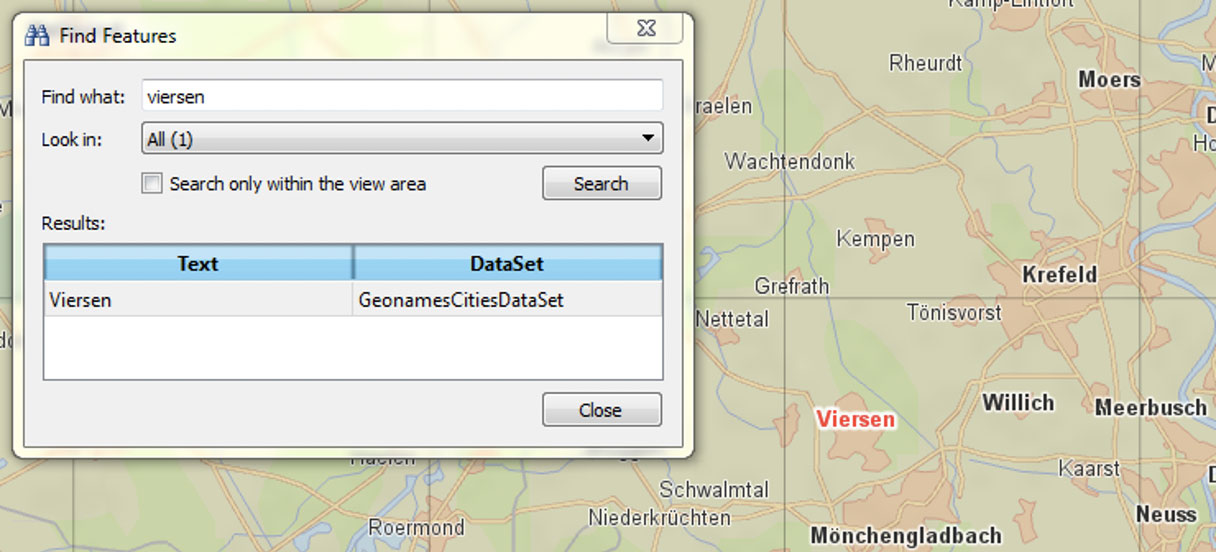
Carmenta Explorer, the Carmenta Engine map configuration viewer, uses the new full-text search index functionality to empower its “Find Features” user interface.
Native Support for connecting to OGC® WFS Map Servers
A Web Feature Service (WFS), provides a way to request vector features from a map server. The interface is standardized by OGC, the Open Geospatial Consortium.
OGC WFS support is now part of the core of Carmenta Engine through the OgcWfsDataSet component. This complements the existing comprehensive support for OGC services in Carmenta Engine – it is also possible to connect to WMS, WMTS and WCS services, as well as to send queries to CSW catalogues.
As a Technical Committee member of the OGC, Carmenta is dedicated to using and promoting open standards. Carmenta Server, our feature-rich map server, also has full support for OGC WFS.
Other Notable Improvements
New API for retrieving Data Source Information
The new DataSetInfo API streamlines the task of retrieving metadata about geospatial data sources on disk and instantiating Carmenta Engine data sets for the sources. It is designed to make it easy to implement a generic “add map” functionality in a Carmenta based application.
Raster Pyramid Functionality for all Data Sources
All Carmenta Engine raster datasets are now able to generate a cache of raster pyramids which speed up access to the data in zoomed-out scales. A cache can optionally also contain the data in its original resolution, which is useful if the data is slow to read in its native format.
Extended Support for MIL-STD-2525C
MIL-STD-2525C is now the new baseline symbology in the Carmenta Engine Tactical Extension, with the addition of full support for tactical graphics (Appendix B).
A MIL-STD-2525C Tactical Overlay in Carmenta Engine
Support for OGC WKT Formatting
Carmenta Engine Geometry instances can now be efficiently serialized to and from OGC WKT, Well-Known Text.
This functionality complements the existing support for OGC WKB (Well-Known Binary) in making it easy to construct spatial SQL statements from Carmenta Engine objects.