A reliable operational picture
One of the main challenges for TRL Accel was the integration of real time data streams from sensors, applications, and multiple platforms into a consistent and reliable Common Operational Picture (COP). They were searching for a solution that would give them a structured and accessible entry point, despite the inherent complexity of geospatial data and modern C2 toolchains.
“ We chose Carmenta because the SDK is specifically designed for geospatial data visualization and analysis, while also supporting modular integration into existing system architectures. Carmenta UAS Mission Kit was particularly decisive for us, as it provides a wide range of sample applications tailored to UAV related use cases. This has enabled us to build targeted pre-developments that align precisely with our customers’ operational requirements.”
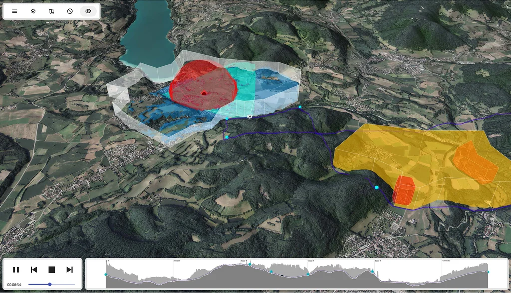
The image is from the Carmenta UAS Mission Kit Sample Application. It shows an operational overview with a target area in grey and enemy 3D line-of-sight analysis in red. A camera line-of-sight analysis from the drone is shown in turquoise, and the blue colour shows the observer line-of-sight from the three waypoints. The UAV route is calculated as a nap-of-the-earth route, avoiding the risky and forbidden areas in yellow and red.
Faster than full in-house development
Onboarding of any new technology takes time; however leveraging Carmenta UAS Mission Kit’s well-structured and thoughtfully designed architecture significantly accelerated TRL Accel’s development and eased their entry into the domain.
“Carmenta UAS Mission Kit provided an excellent foundation for our feasibility studies. The core functionality we needed was already available, allowing us to immediately expand on additional ideas and concepts.”
Another aspect of Carmenta UAS Mission Kit that has been crucial to the rapid progression is the combination of support, documentation, and hands-on training.
“Our customer is highly satisfied with the current results, which demonstrates that Carmenta UAS Mission Kit enabled us to reach a professional level much faster than would have been possible with a full in house development from scratch.”
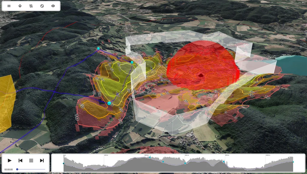
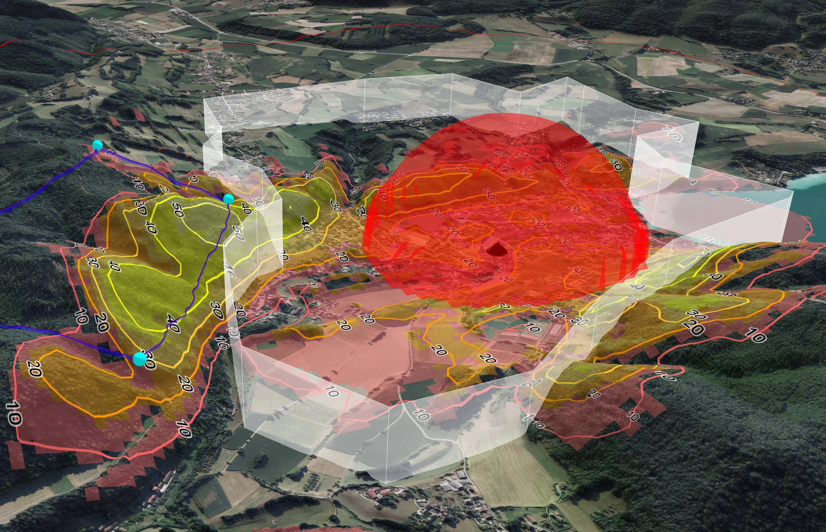
The image shows a target area in grey, with an intervisibility analysis showing how much of the target area that is visible from each point. In the middle, in red, is an enemy 3D line-of-sight analysis. With the help of these analyses the turquoise waypoints have been placed and a UAV route generated. The image is from the Carmenta UAS Mission Kit Sample Application.
Key UAS functionalities
Several of the functionalities in Carmenta UAS Mission Kit have been valuable to the development. These include:
- The mission planning capabilities with modular, configurable waypoints, particularly the built in nap of the earth routing, have been essential.
- TRL Accel relies heavily on radio coverage analysis and the ability to define restricted zones, which will serve as core building blocks for upcoming features.
- They also benefit from the line of sight and terrain analysis modules, as well as the ability to overlay real time UAV video feeds and telemetry data.
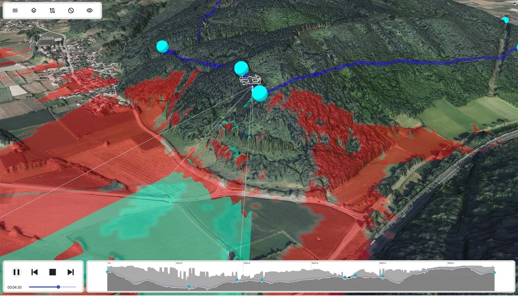
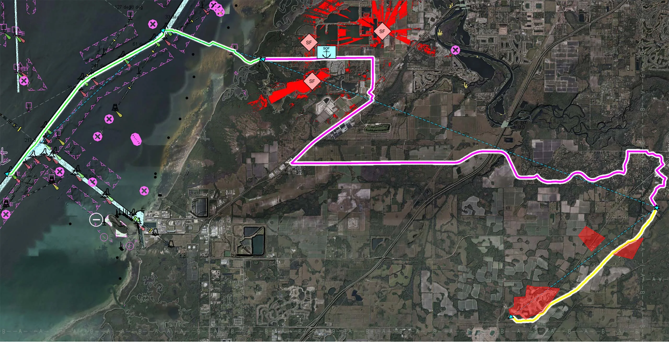
The image is from the Carmenta UAS Mission Kit Sample Application. It shows a drone flying along a nap-of-the-earth route, avoiding the red areas with too low radio reception as calculated by the radio coverage analysis. It also shows the camera line-of-sight analysis of what the drone will be able to record during flight, in turquoise.
From concept to capability
Like any advanced SDK, onboarding requires time and exploration. But the combination of structured training and documentation, example projects, and access to Carmenta experts ensured clean and well informed architectural decisions early in the process. The provided resources help TRL Accel maintain consistency from configuration in Carmenta Studio to visualization in their application.
“We would definitely recommend Carmenta UAS Mission Kit. It is particularly beneficial for companies working in UAV mission planning or tactical situational awareness. Our own submodules integrated seamlessly into the existing architecture, demonstrating the system’s flexibility. It is an ideal solution for teams seeking a scalable, modular platform that goes beyond standard GIS products, including newcomers to the domain.”