Carmenta Concludes Innovative Project on Autonomous Drone Flights in Heathrow Airport’s Flight Restriction Zone (FRZ)

Carmenta is proud to announce the conclusion of the HADO® project, paving the way for safe and autonomous drone flights in urban environments and high-intensity airspace.

The project, which has involved extensive development, collaborations and flight trials in Heathrow Airport’s Flight Restriction Zone (FRZ), has shown great potential for safe and efficient autonomous drone operations in highly congested urban environments.

Project Overview

Project HADO® (High-intensity Autonomous Drone Operations), was initiated by the UK innovaton agency, Innovate UK, in 2022. Part of the Future Flight Challenge program, it involved a consortium of partners consisting of Carmenta, Operational Solutions Limited (OSL), Thales, Herotech8, London Heathrow Airport, Cranfield University, Dynamic Intelligence Solutions, and UAVTek.

The goal of the project has been to demonstrate that multiple drones can be safely and autonomously operated beyond visual line of sight (BVLOS) in high-intensity environments, in this case within one of the world’s busiest and most complex airspaces, London Heathrow Airport. The broader implications of the initiative is to unlock the potential for a commercial deployment of autonomous unmanned aerial systems (UAS) in high intensity environments.

The final flight trials were conducted in Heathrow Airport’s Flight Restriction Zone (FRZ), and the outcomes from the project show great potential for autonomous drone operations in these types of environments.

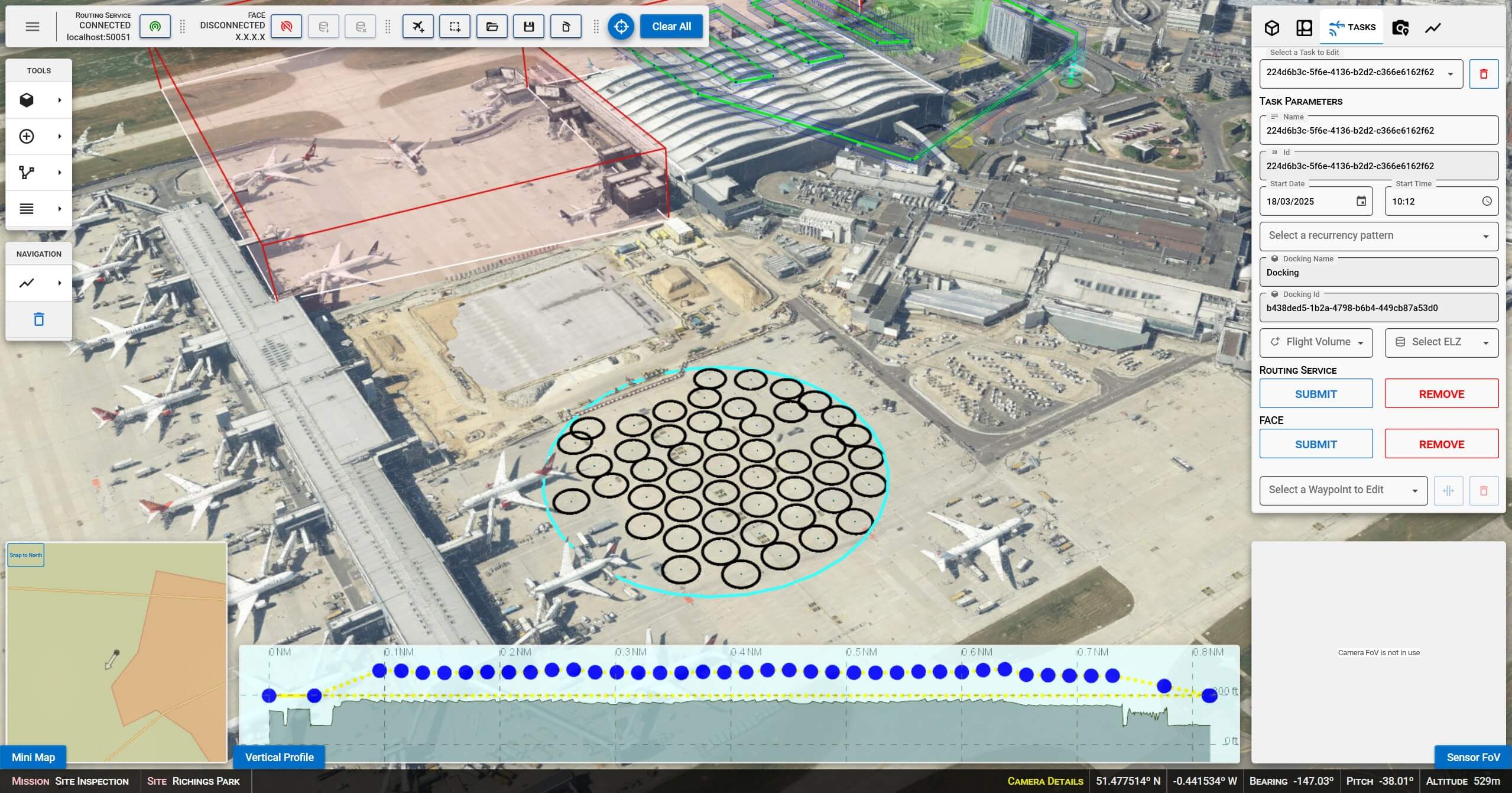
Use Cases and Applications

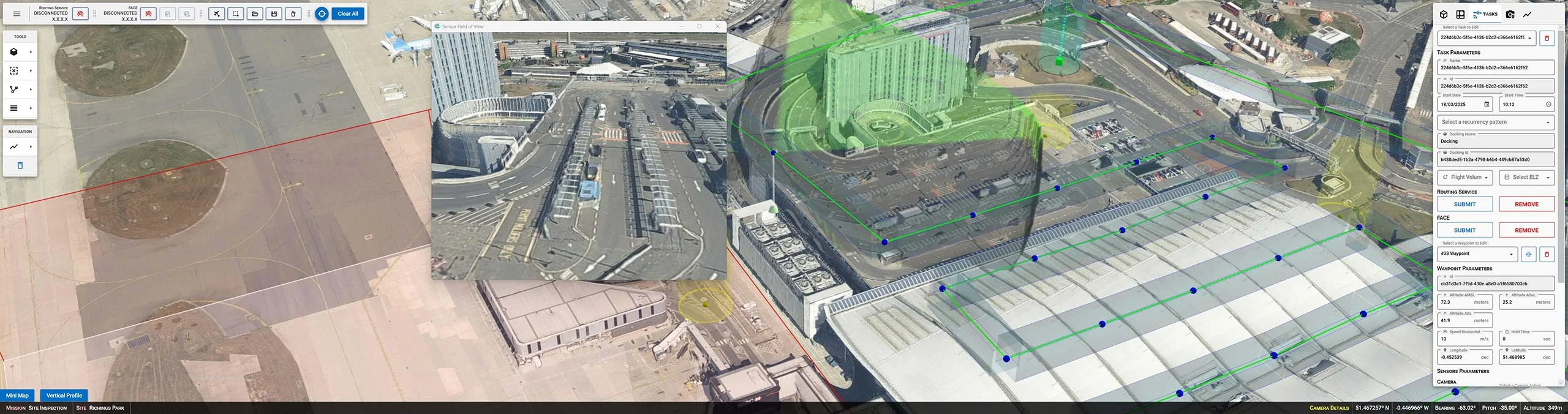
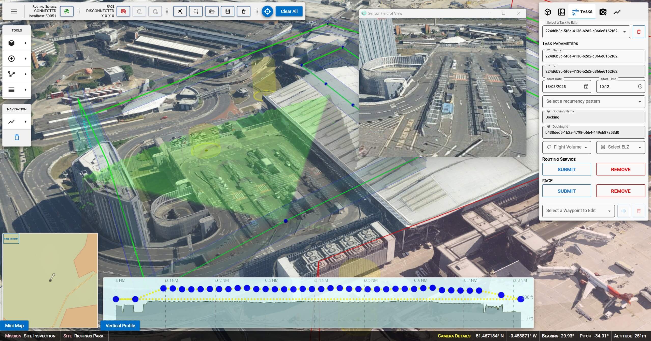
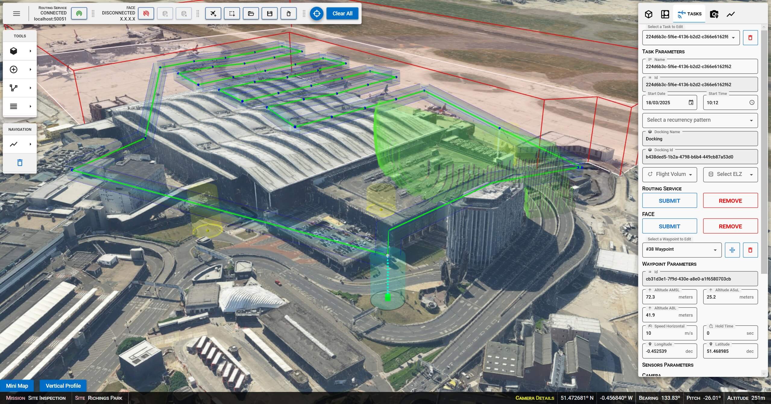
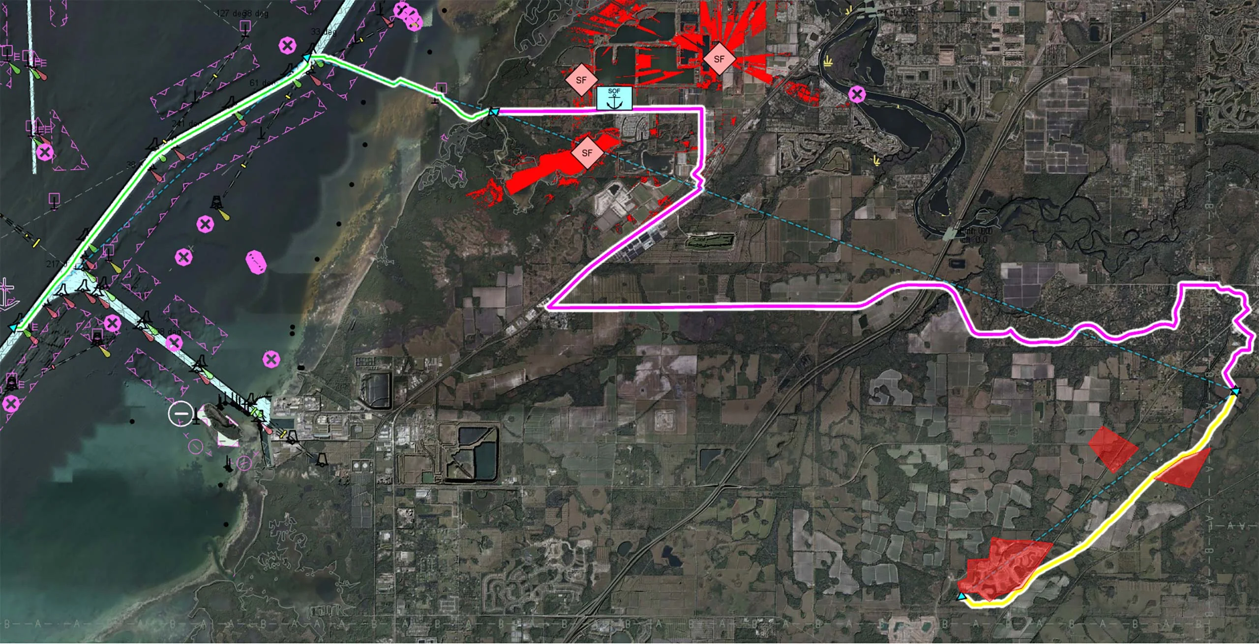
The project explored various use cases for autonomous drone operations, including perimeter surveillance, infrastructure inspection, and incident response. Capabilities developed by Carmenta in the project includes a 3D Graphical User Interface to plan UAS Missions and a set of backend services. The backend services were created to process flight plans, generate optimised routes for fence inspection, roof inspection, building inspection, apply route and obstacle deconfliction, and recommend landing zones for emergency procedures.

To generate optimal routes, obstacles such as buildings, restriction areas, overlapping UAS flight corridors, and sensor coverage need to be considered. If conditions for a route change, the route has to be regenerated and adapted in real-time.

Successful Trials and Outcomes

End of 2024, flight trials were conducted within Heathrow Airport’s Flight Restriction Zone (FRZ), aimed to demonstrate drone operations using an innovative UTM-based approval and deconfliction process.

The trials demonstrated the robustness and reliability of the developed systems. The results showcase operational benefits such as increased automation and faster turn-around times, and the possibilities ahead to continue working towards fully autonomous BVLOS flights in urban environments.

Another outcome from the project is recommendations on regulations, to enable fully autonomous BVLOS flight operations in dense urban environments.

Drone Flight Trial at Heathrow FRZ

Carmenta technology – A key component in HADO®

Throughout the project, Carmenta technology has played a crucial role, providing geospatial visualization and analysis for safe autonomous drone operations. Carmenta has developed and provided a range of sophisticated functionalities, including:

  • Mission Planner (frontend)
    A Mission Planner with 3D graphical user interface to plan UAS missions. This includes defining Task-Specific Configuration Data and Site-Specific Configuration Data.
  • Routing Service (backend)
    A routing service used to process flight plans and generate optimized and deconflicted routes that avoid conflicts and adheres to safety guidelines.
  • API:s
    The FACE platform integration is a backend service to process flight plans and generate optimized routes that avoid conflicts and adheres to safety guidelines. A Cloud Interface with a set of endpoints to provide geospatial services for routing, pattern generation, elevation and obstruction analysis.

Key Functionalities and Capabilities

Defining Site Data

  • Takeoff/Landing Sites
    Identifying docking stations and emergency landing zones to facilitate safe drone operations.
  • Avoiding Restricted Areas
    Implementing geofences to prevent drones from entering restricted zones.
  • Enforcing Area of Operation
    Utilizing geocages and airspace management to define operational boundaries.

Mission Planning

  • Route Definition
    Adding waypoints with specific actions to create detailed flight routes.
  • Line-of-sight
    Taking into account not only the flight path but also line-of-sight and camera views.
  • Real-time Adjustments
    Adjusting camera parameters in real-time and receiving feedback through simulated camera views.

Pattern Generation

  • Inspection, Search & Rescue, Photogrammetry
    Creating flight patterns tailored for specific missions.
  • Using 3D Models and Terrain
    Leveraging high-resolution 3D models and terrain data.
  • Waypoint Positioning
    Positioning waypoints based on sensor specifications and required resolution.

Route Generation

  • Best Route Calculation
    Generating the best route between waypoints, while deconflicting site data, buildings, terrain, and other routes.
  • Drone Characteristics
    Considering the specific characteristics of the drones.
  • Real-time Calculation
    Continuously reflecting the current situation in route calculations.

Mission Preview

  • Simulation
    Simulating the planned mission
  • Line-of-sight
    Line-of-sight and field of view preview

Mission Execution

  • Route Recalculation
    Adjusting routes in response to dynamic hazards and the current situation.
  • Current Position
    Using the drone’s current position to inform recalculations.

Learn more: UAS Mission Planning use case

Future Implications

As urban areas continue to grow and evolve, the ability to safely integrate autonomous drones into the airspace will become increasingly important. The successful conclusion of this project opens up commercial use of autonomous unmanned systems (UAS) at airports or in cities.

The tools and capabilities developed by Carmenta also pave the way for further developments and we remain committed to advancing the field of autonomous drone technology. For example, the developed technology has already used as a stepping stone for further developments and adjustments in an autonomous drone project with the Swedish Armed Forces. We are looking forward to continuing to explore new opportunities and collaborations to further enhance the capabilities and applications of autonomous drones.

Related knowledge

Whitepaper: Resupply with UAVs

Whitepaper: Resupply with UAVs

Military last-mile resupply using UAS technology with geospatial analysis. Real-time geospatial analysis for UAVs can be used to cope with dynamic challenges, enhancing situational awareness on the battlefield and supporting both human and autonomous decision-making.

Read more