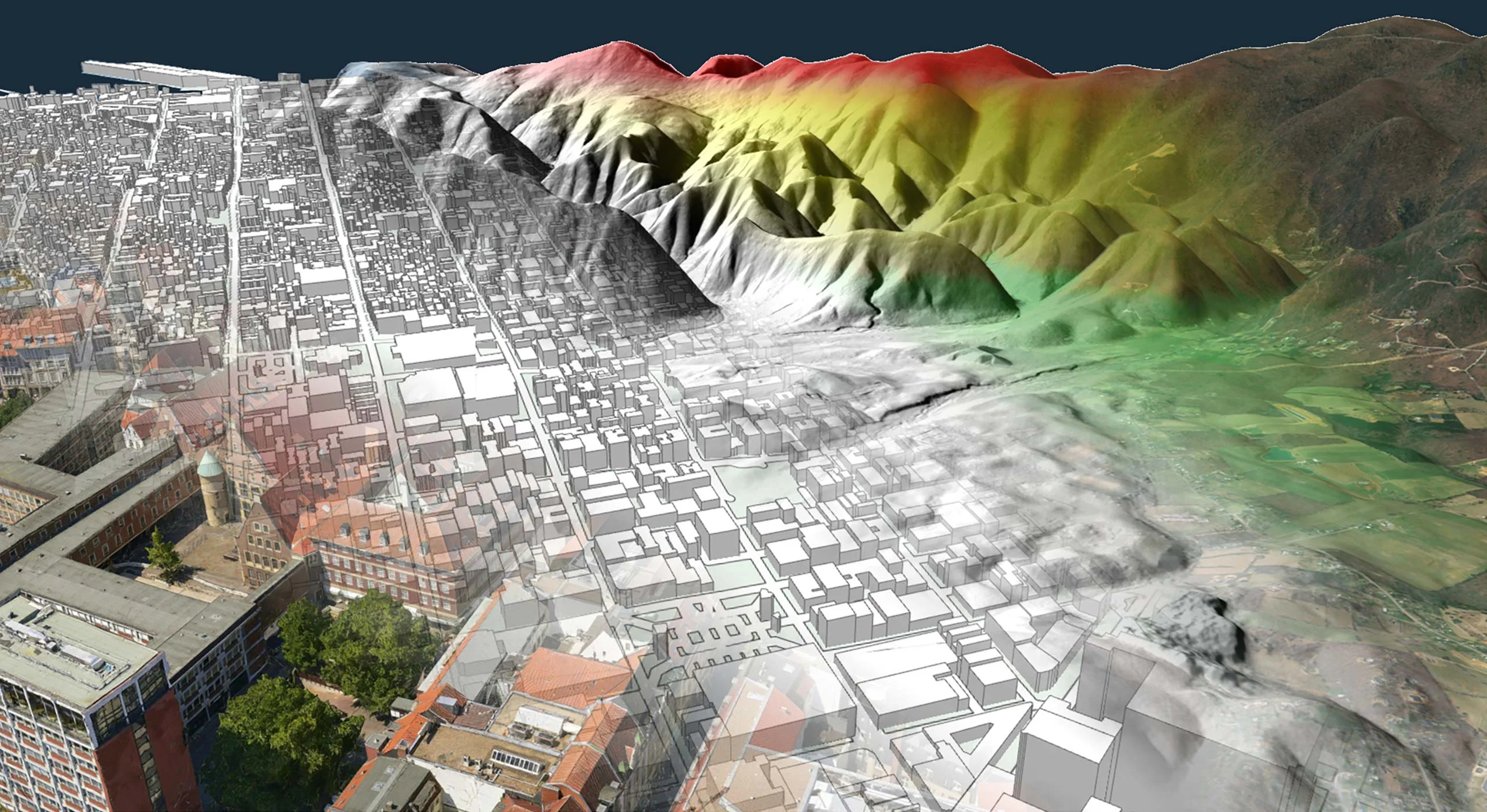
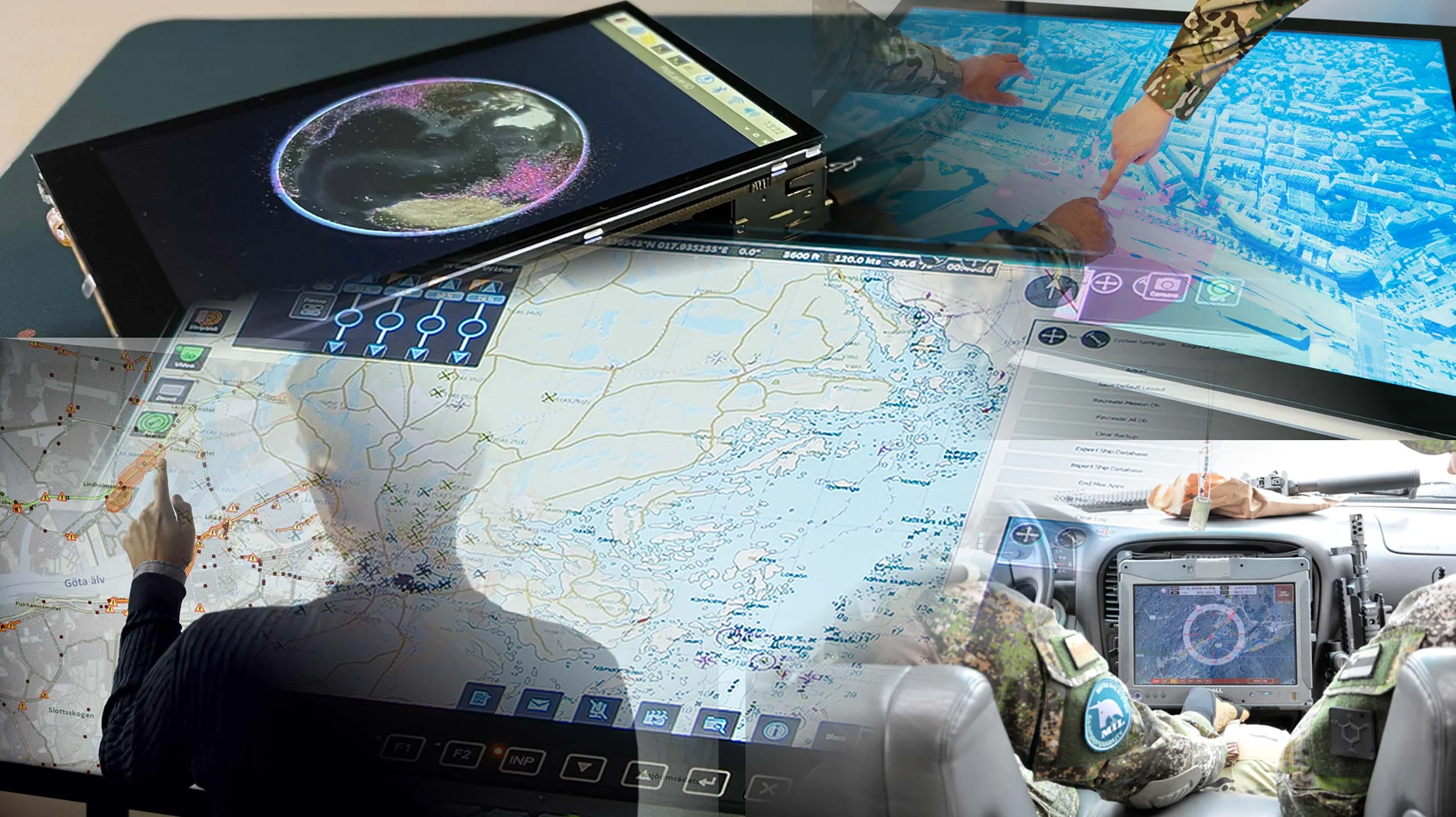
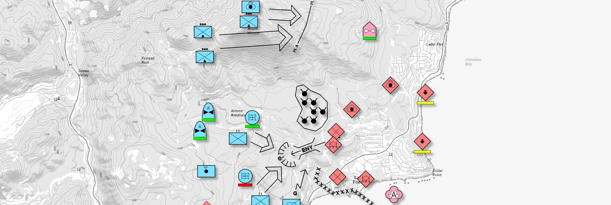
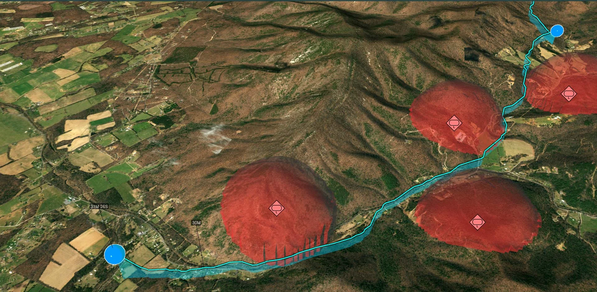
Extensions

Carmenta Engine 5.15

1-CarmentaEngine_Extensions_5

3D EXTENSION

  • Enables interactive 3D fly-throughs with dynamic loading of data.
  • On the fly generation of 3D worlds straight from 2D/3D GIS data in any format supported by the Engine – no 3D modeling is needed.
Read more

The Carmenta Engine 3D Extension makes it easy to create stunning 3D maps, without the need for 3D modelling. Generate realistic 3D environments using any 2D or 3D geospatial data format supported by Carmenta Engine.

The 3D ground surface is generated on the fly using either elevation raster data or 3D point clouds, and can be textured with any combination of 2D map layers.

The generated ground surface can be seamlessly combined with detailed 3D meshes, e.g. to display 3D city models.

3D models in OpenFlight, COLLADA, OBJ, 3D Studio, glTF  and VRML formats can be used to represent objects like aircrafts and vehicles in the view. 3D features can also be automatically created from 2D data. For example, you can easily generate blocks of buildings from 2D building outlines or semi-transparent areas that represent specific airspace zones in an aeronautical map.

The Visibility Extension makes it possible to perform real time line-of-sight calculations on detailed 3D mesh data.

The Terrain Warning Extension enables the 3D environment to be dynamically colourised according to the distance from the aircraft.
For an even more realistic environment, Carmenta Engine 3D maps can be integrated with SilverLining™ from Sundog Software to give your maps natural-looking weather conditions.

Close
CE_5

TERRAIN VEHICLE ANALYSIS EXTENSION

  • Extension for calculating how ground-based manned and autonomous vehicles can interact with the terrain and the roads.
  • Makes it possible to calculate optimal off-road routes for terrain vehicles based on road and ground conditions, operational constraints and vehicle characteristics.
  • Provides information on the terrain accessibility, through the calculation of isochrones (travel times) or local speeds.
Read more

A comprehensive solution for itinerary calculation and accessibility analysis

In various systems, the mobility of terrain vehicles is a key component. Fire trucks dispatched to fight forest fires need to calculate the fastest route through uneven terrain. In force operations, to plan a mission successfully, an officer wants to ensure safe travel for allied vehicles, while anticipating the next moves of enemy forces. Carmenta offers highly dynamic and modular routing functionalities to answer the needs of mission-critical systems.

Combine map data and operational information

Most navigation systems in transport are oriented towards the search for optimal paths following the road network only, but cross-country navigation presents much more complex circumstances to take into account. When advancing through terrain, an optimal route also depends on the slope and the type of soil. The Carmenta Engine terrain vehicle analysis provides comprehensive support for defining these terrain characteristics using elevation, land cover and road network map geographical data in any format supported by Carmenta Engine.

In addition, the Carmenta Engine routing module makes it easy to add dynamic information about operational constraints. In many tactical scenarios, access to normally traversible areas can be restricted by the operator. Such forbidden areas can for example be defined from real-time weather data, highlighting flooded fields or areas with low visibility; or they can come from an analysis of enemy line-of-sight, a too dangerous area to enter. The routing algorithm gauges which areas are impossible to reach or enter under any circumstances, and which areas are passable but not recommended to enter, and then optimises the itinerary accordingly.

A streamlined terrain vehicle model makes it easy to define characteristics, such as the maximal speed for each terrain condition or for each road, as well as dimensions, weight and more. Combining map data, operational constraints and vehicle types makes the terrain routing calculations a process tailored to the requirements of any system.

Analyse mobility and accessibility

Additionally, Carmenta Engine makes it possible to calculate omnidirectional travel times from a specified starting point, resulting in so-called isochrones. Based on calculated isochrones, an operator evaluates how far a vehicle can drive in a certain time, what are the best points of entry to reach a target location, or makes rough predictions where an enemy vehicle could be in a certain amount of time. The integration of isochrones as a color-coded overlay into a map makes it easy in a single glance to evaluate the mobility of vehicles.

Close
Vertical Profile

VERTICAL PROFILE EXTENSION

  • Generates a vertical profile along routes, cutting through both terrain and vector data sources such as airspaces.
  • Integrate outputs from other analyses such as line-of-sight.
  • Dynamically adjust the altitude of the route waypoints in the vertical profile.
Read more

Using 2D maps gives a good overview on a situation and powerful options to plan routes, but it is often harder to understand the profile of the terrain followed by the route, and the obstacles encountered. Having access to a vertical view of a defined route is a key feature in a lot of aeronautical applications, as well as mission panning or battle management systems for ground-based vehicles. The Carmenta Engine Vertical Profile Extension helps the operator ensure that the route doesn’t encounter forbidden airspaces, or that the slopes are not too steep.

The extension generates a vertical profile along a route or a flight corridor, cutting through both raster and vector data sources, such as elevation, terrain classification, airspaces, road network, and more. The geospatial data can be accessed in real time, using any of the 70 geospatial data formats that Carmenta Engine supports, including common military formats like Digital Terrain Elevation Data (DTED).

In addition, outputs from other Carmenta Engine analyses, such as the line-of-sight functionality, can be used as a terrain analysis input, to answer questions like, “does the route intersect the line of sight of any threats?”

The Vertical Profile analysis benefits from Carmenta Engine’s core functionality, and the resulting profile view constitutes a separate Carmenta Engine map, making it easy to apply the same color-coded visualisation and vector symbology to the profile as to the 2D and 3D maps. The extension also supports interactions such as dynamically adjusting the altitude of each waypoint of the route in the vertical profile view.

Close
Terrain Analysis

VERTICAL CLEARANCE EXTENSION

  • Dynamically calculates the terrain and obstacle clearance in a corridor around flight routes.
Read more

Efficient utilisation of terrain and obstacle data sources is a key feature in a lot of aeronautical applications. To this end, the Vertical Clearance extension provides a highly configurable functionality to calculate the terrain and obstacle clearance along flight routes.

The clearance analysis benefits from Carmenta Engine’s core functionality. Terrain and obstacle data can be accessed in real time, using any of the 70 geospatial data formats that Carmenta Engine supports, including common military formats like Digital Terrain Elevation Data (DTED). The flight route and its corridor can both be dynamically updated in real time from the map, and the clearance calculated on-the-fly using the new route.

The result of the clearance calculation can be visualised as overlays in a 2D map, to provide decision support during mission planning for example. The different overlays can highlight any areas and obstacles which are too close to the aircraft flight level within the flight corridor. The Vertical Clearance extension can also calculate so-called critical terrain spots, having either the highest elevation or the lowest leg clearance, and display various information about their altitudes.

Combined with the Vertical Profile extension, the Vertical Clearance ensures that aeronautical operations can be planned or executed in the safest manner.

Close
engine58-terrain-color

TERRAIN WARNING EXTENSION

  • Dynamic terrain colouring in 2D and 3D to indicate the distance to the aircraft.
  • Performed on the graphics card for boosted performance.
Read more

The Terrain Warning Extension enables you to apply a colour-coded terrain awareness visualisation to both 2D maps and 3D environments.

Carmenta Engine evaluates the altitude difference between a flying aircraft and the ground, within a certain radius around the aircraft. Using the calculated altitudes, an entirely configurable colour overlay is applied directly to the map views, making it a must-have feature in any system that tracks live aircrafts, such as UAV ground control stations.

The analysis is performed using elevation data in any of the 70+ geospatial data formats that Carmenta Engine supports. Additionally, the extension can also take into account detailed 3D city environments, where the colour-coded visualisation is not only applied to the terrain, but also to building roofs and treetops.

The Terrain Warning analysis and visualisation is done on-the-fly by the graphics card, making it very efficient to track a live aircraft location and re-calculate the terrain warning relative the new position and altitude.

Close
6-CarmentaEngine_Extensions_5

VISIBILITY ANALYSIS EXTENSION

  • Extension for performing high performance visibility calculations in both 2D maps and 3D city environments.
  • Extremely rapid – designed to be computed on-the-fly for moving objects.
  • Also provides high-performance calculation of intravisibility between multiple moving objects, useful for target tracking
Read more

Visibility Analysis

The Carmenta Engine Visibility Analysis Extension allows you to perform high performance visibility calculations in both 2D maps and 3D city environments.

The line-of-sight calculation uses elevation data to compute the regions that have a free line of sight to the position of an observer. The computation is extremely rapid – it is designed to be computed on the fly for moving objects. Multi-resolution data sources can be used to further improve the performance of the calculation.

The result of the calculation consists of raster values that specify at which altitude an object has to be in order to be seen at a certain position. This can be used to create a colour coded display of the result. The result can also be intersected and visualised in a vertical profile. Many configurable sensor parameters, such as lobe size, maximum range and refraction means that the calculation can also be used for determining the line of sight from regular or phased array radar systems.

Line of sight in 3D city environmentsS

In 3D, the line-of-sight analysis can be performed directly on the ground meshes that have been loaded into the view. This allows for a very accurate result, especially when used with detailed 3D city models.

Additional Features

The extension provides high performance calculation of intravisibility between multiple moving objects -especially useful for target tracking. Another component makes it possible to determine the optimal positions for surveying a specific area. Also included in the extension is functionality for computing the shadows cast by terrain features such as mountains on a specific time and day.

Close
GRIB2.px

METEOROLOGICAL EXTENSION

  • Read and visualize meteorological data without any need for preprocessing.
Read more

Instant visualization of GRIB files

The GribDataSet makes it possible to read meteorological data in the GRIB format, and the output can be used as any raster in Carmenta Engine, either for direct visualization, or as input to other geoprocessing operators.
With the PointSampleOperator you can sample raster values into attributes on point features, and this can be used together with the new WindBarbSymbol that makes it easy to visualize wind direction and speed.

Features

  • GribDataSet makes it possible to read GRIB files, both version 1 and 2, in Carmenta Engine.
  • WindBarbSymbol makes it possible to easily visualize wind direction and speed.
Close
radarvideo

RADAR VIDEO EXTENSION

  • Extension for hardware accelerated rendering of Radar Intensity Displays.
Read more

Hardware Accelerated Rendering of Extremely Dynamic Objects

The Carmenta Engine Plot and Radar Video extensions are supplementary packages for systems that need to display radar plot overlays, radar intensity displays and other highly dynamic layers. Thanks to a highly optimized, GPU accelerated rendering pipeline, these extensions can handle millions of continuously moving objects.

Mission critical systems often need to handle real time data streams from external sensors such as radars. Handling such data streams can be challenging, especially when it comes to keeping the map display up-to-date with the rapidly changing information.

The Carmenta Engine Plot and Radar Video extensions are designed to make this task easy. The high performance of the components ensures that applications will be able to handle virtually any amount of plots, as well as continuously updated intensity displays, without slowing down the system.

Features

  • Plots and radar video can be overlayed on any Carmenta Engine map – benefit from the support for 70+ data formats and high fidelity rendering to create a highly usable map display.
  • The extensions are available for all Carmenta Engine versions – it runs both on Windows, Linux and Android.

Plot Extension Features

  • GPU accelerated rendering pipeline (OpenGL or DirectX) can handle millions of continuously updated plots.
  • Optimised API (available for C++, .NET and Java) allows the application to handle plots in batches to minimise overhead.
  • Plots can be rendered either as coloured dots or using external symbol files.
  • The plot opacity can be dynamically updated. This makes it easy to e.g. smoothly fade out old plots.

Radar Video Extension Features

Optimised API (available for C++, .NET and Java) allows the application to pass in individual sweeps from the radars to efficiently update an intensity image. The color and opacity of the intensity images is fully customisable.

Close
3-CarmentaEngine_Extensions_5

GEOREFERENCED VIDEO EXTENSION

  • Makes it possible to georeference full motion video streams on the fly in order to display the video overlayed on the map.
Read more

Overlay Full Motion Videos onto your Carmenta maps – from any source

Real time video overlays can provide a crucial advantage for UAV Ground Control Stations and other systems that manage tactical video intelligence.

Overlaying a live video stream onto a map, from a UAV or other source, significantly increases the usability of the video, as everything that happens in the video is immediately georeferenced.

The modular architecture of the Carmenta Engine Georeferenced Video Extension enables you to program your own code to read both the video stream and the camera metadata, using any of the APIs supported by Carmenta Engine (C++, C# or Java) – which means you can use videos from any source.

To make getting started easier, the extension comes with a sample video and associated camera metadata, this metadata could be extracted from a video stream encoded in accordance with the Motion Imagery Standards Board (MISB) 0601 and NATO STANAG 4609 standards.

Close
4-CarmentaEngine_Extensions_5

TACTICAL EXTENSION

  • Extension for creating, managing and visualising tactical symbols according to the DOD MIL-STD-2525 and NATO App-6 standards.
Read more

Powerful support for military overlays

Tactical Extension is a supplementary package that makes it easy to implement support for military overlays in your Carmenta Engine-based applications.

Tactical Extension supports tactical symbols and graphics according to the MIL‑STD‑2525 and STANAG 2019 APP-6 standards, and also contains a multitude of features that facilitate the development of C4ISR applications.

Carmenta Tactical Extension is a powerful development tool designed to meet the challenges faced when integrating complex military overlays in a Command and Control System. The data-driven visualisation and comprehensive symbol management ensure that the presentation is always kept up-to-date. With Tactical Extension it is easy to implement real-time situation displays that include advanced symbology.

Tactical Extension has been seamlessly integrated with Carmenta Engine and extends its already powerful overlay capability to a new level.

Carmenta Engine Tactical Extension contains the following components:

  • Ready-to-use implementation of the MIL-STD-2525B (change 1), MIL-STD-2525C, MIL-STD-2525D, and NATO STANDARDS APP-6B and APP-6D, symbol standards.
  • Supports MIL-STD-2525 Appendix A, B, D and E.
  • For APP-6B all point symbols in the 1.X hierarchy are supported.
  • Provides an API for handling the full MIL-STD-2525 and APP-6 metadata. The metadata contains descriptions of the tactical symbols and can be used to create data-drive symbol editor dialogues.
  • A group storage component for advanced support for hierarchical grouping of tactical symbols with functionality for automatically generating convex hulls around groups. The convex hull polygon is calculated in real-time and works with moving objects.

Key Features

  • Visualisation parameters such as size, affiliation colors, transparency, halo, fill and icon can be set individually per object or collectively per layer.
  • Tactical symbol are specified using SIDC identifiers which makes it very easy and quick to define tactical objects.
  • Supports dynamic moving and rotating 2D and 3D views.
  • Easy-to-use APIs for .NET, Java and C++.
  • Support for hardware accelerated graphics and display of several thousands of moving tactical symbols, even on low-end rugged systems.
  • Built-in support for creating and interacting with tactical symbols and and graphics.
Close

MILITARY GEODATA FORMATS EXTENSION

  • Adds functionality for reading military geographic data in CMRG (PCMap), DFAD and RPF (CADRG and CIB) formats.
8-CarmentaEngine_Extensions_5

AERONAUTICAL DATA FORMATS EXTENSION

  • Reads aeronautical navigation database files on the ARINC SPECIFICATION 424-16, 424-17 and 424-18 formats, as well as the AIXM 5.1 and 5.1.1 formats.
CE_5.14

AIRSPACE COVERAGE EXTENSION

  • Makes it possible to analyse how well a number of different sensors cover a specific airspace of interest.
Read more

The Airspace Coverage Extension makes it possible to merge a number of viewshed volumes into a combined volume that represents airspace covered by a sufficient number of observers.

The functionality can also be used to show the parts of an airspace that lacks sufficient coverage, as in the picture below.

airspacecoverage
Close
engine56-radar-plot

PLOT EXTENSION

  • Extension for efficient rendering of radar plots and other extremely dynamic information.
  • Easily handles millions of continuously updating plots.
Read more

Hardware Accelerated Rendering of Extremely Dynamic Objects

The Carmenta Engine Plot and Radar Video extensions are supplementary packages for systems that need to display radar plot overlays, radar intensity displays and other highly dynamic layers. Thanks to a highly optimized, GPU accelerated rendering pipeline, these extensions can handle millions of continuously moving objects.

Mission critical systems often need to handle real time data streams from external sensors such as radars. Handling such data streams can be challenging, especially when it comes to keeping the map display up-to-date with the rapidly changing information.

The Carmenta Engine Plot and Radar Video extensions are designed to make this task easy. The high performance of the components ensures that applications will be able to handle virtually any amount of plots, as well as continuously updated intensity displays, without slowing down the system.

Features

  • Plots and radar video can be overlayed on any Carmenta Engine map – benefit from the support for 70+ data formats and high fidelity rendering to create a highly usable map display.
  • The extensions are available for all Carmenta Engine versions – it runs both on Windows, Linux and Android.

Plot Extension Features

  • GPU accelerated rendering pipeline (OpenGL or DirectX) can handle millions of continuously updated plots.
  • Optimised API (available for C++, .NET and Java) allows the application to handle plots in batches to minimise overhead.
  • Plots can be rendered either as coloured dots or using external symbol files.
  • The plot opacity can be dynamically updated. This makes it easy to e.g. smoothly fade out old plots.

Radar Video Extension Features

Optimised API (available for C++, .NET and Java) allows the application to pass in individual sweeps from the radars to efficiently update an intensity image. The color and opacity of the intensity images is fully customisable.

Close
heatmap

HEATMAP EXTENSION

  • Adds functionality for dynamically generating point density rasters which can be visualised as heatmaps.
5-CarmentaEngine_Extensions_5

NAUTICAL CHART EXTENSION

  • Extension for reading and rendering Nautical Charts according to the IHO S-57, S-63 and S-52 standards.
  • Reads and portrays both ENC and NATO AML data.
Read more

Combine S-57 and S-63 Charts with Maps and Overlays

The Carmenta Engine Nautical Chart Extension is a supplementary package for adding nautical charts to Carmenta Engine-based applications. The extension provides native, high-performance reading and rendering of maritime data according to the International Hydrographic Organisation (IHO) S-57, S-63 and S-52 standards.

Combine charts and maps

Many Command and Control systems lack adequate map presentation over maritime areas. Conversely, the map display in many maritime systems would benefit from data sources like satellite imagery and town plans.

The Nautical Chart Extension bridges this gap by enabling systems to combine S-57 and S-63 charts with maps in any of the 70+ formats supported by Carmenta Engine.

The Nautical Chart Extension supports both ENC and NATO AML (Additional Military Layers) S-57 layers, as well as commercial charts protected by the S-63 Data Protection Scheme.

Cost effective data management

One of the greatest benefits of using the extension is that it allows you to read the maritime data directly from the S-57 or S-63 files. This means that time consuming offline data preparation work can be eliminated altogether. When you receive charts from the data provider, just copy them to your computer and they will immediately be available in your system.

Standardised chart presentation

The extension provides ready-to-use nautical chart presentation according to the S-52 Presentation Library 4.0 and the NATO AML Portrayal Specification 2.0. It is also possible to apply custom processing and visualisation to individual S-57 features using the complete Carmenta Engine function set, e.g. to remove or highlight certain objects.

Real time performance

The Nautical Chart Extension benefits from the full set of performance-enhancing features contained in Carmenta Engine. These include hardware accelerated graphics, multi-core support and sophisticated caching. This means that the charts can be used for real time and rotating moving map systems with outstanding results.

Ongoing development

The Carmenta Engine Nautical Extension is under active development to meet the needs of our customers. Work is currently ongoing to add support for the S-102 Bathymetric Surface Product Specification.

Close

C-MAP CM93 EXTENSION

  • Adds support for reading C-MAP CM93 nautical charts and visualising them according to the IHO S-52 standard.

CATALOG EXTENSION

  • Gives Carmenta Engine based applications a structured way to handle background maps.
  • A Catalog can be instantiated either from a local folder or from OGC compatable cloud based infrastructure.
  • Retrive maps and data based on keywords or other criteria.
Read more

The Carmenta Engine Catalog Extension is a framework for providing applications with map configurations and corresponding data in a uniform way. Using a catalog like this decouples the application development from the data management, and the application developer does not need to know exactly which maps will be available on a deployed system. The application can retrieve a list of available maps and let the user select one, or it can rely on the data provider that there is always at least one map available with a certain name or other keyword.
It is possible to install new map configurations and data into an existing catalog, for instance covering new parts of the world, and the application will automatically detect the new data. Existing map configurations and/or data may be updated without changing the application, and new data will be added to existing map configurations.

Catalog maps may be packaged into reusable units that can be deployed to many sites, and be used by many different applications. A large organization developing and maintaining several different applications may dedicate a part of the organization to produce these map packages, and relieve the application developers from having to manage the map data.
The services and functions provided by a Carmenta Engine catalog may use both local map configurations and data, and server based CS/W, WMS, WMTS, WCS and WFS services. The application uses the exact same API regardless of whether the services are local or remote. This makes it easy to move from local data to cloud based infrastructure, or to combine the two alternatives.
The Carmenta Map Builder application (sold separately) gives end users an easy way to add new maps to the catalog.

Close

SPATIAL DATABASE EXTENSIONS

Extensions for reading geospatial data from different kinds of database systems:

  • Microsoft SQL Server Extension
  • MySQL Extension
  • Oracle Spatial Extension
  • PostgreSQL/PostGIS Extension

DWG AND DXF EXTENSION

  • Extension for reading CAD databases in DWG and DXF, the AutoCad file formats.